geojson.app
Open source mapping & geospatial data visualization.
A browser-based GeoJSON workbench. Drop, paste, or URL-load geospatial data and instantly visualise it on an interactive vector map — with measurement, drawing, and an embeddable JS SDK. No proprietary tile lock-in.
- Geospatial
- Open source
- Developer tools
- Mapping
- Stack
- Open source
- Login required
- Never
- Embeddable
- JS SDK
- Cost
- Free
The story
What it is and why we built it
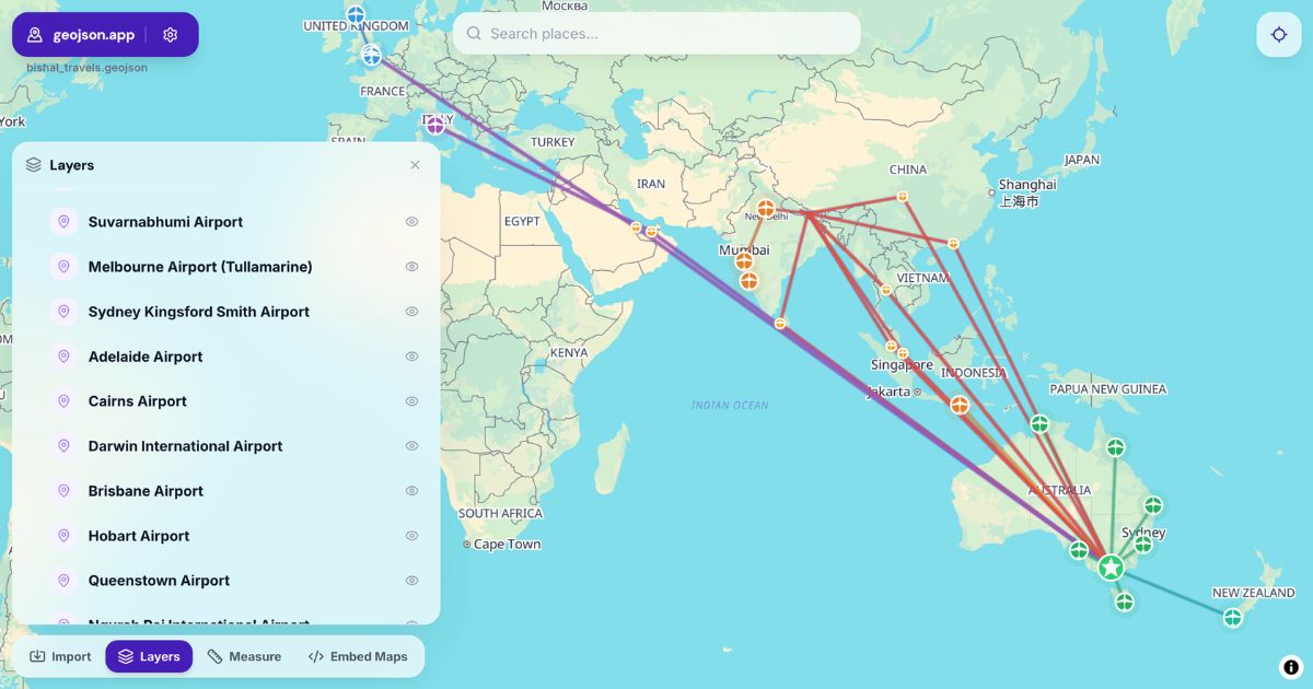
geojson.app is a geospatial data visualisation and processing toolkit built on a purely open-source web mapping stack. Drag a .geojson file in, paste raw GeoJSON, or load it from a URL — the map renders instantly with vector tiles, no account required.
Beyond viewing, the workbench gives you measurement, marker placement, polygon drawing, projection toggles, and a one-click "copy as GeoJSON" export for any feature. For developers, an embeddable JS SDK makes it trivial to add an interactive map to your own site without committing to a paid Mapbox or ArcGIS account.
It exists as the open-source alternative we wanted: fast, no-login, no lock-in, and built on tools the wider geospatial community can audit and extend.
What's inside
Features
- 01
Drag-and-drop GeoJSON
Drop a .geojson file onto the workbench or paste raw JSON and it renders on the map immediately. No accounts, no upload limits.
- 02
Load from URL
Pull GeoJSON straight from a URL — share a link to a hosted dataset and the map renders with the data inline.
- 03
Measure, draw, mark
Measure multi-point distances, draw polygons and multi-polygons, drop markers with custom positioning — all from the toolbar.
- 04
Copy as GeoJSON
Any drawn or selected feature can be copied straight back out as valid GeoJSON. The workbench is a two-way street.
- 05
Embeddable JS SDK
Add interactive maps to your own website using the JS SDK — no paid tile provider required for typical use.
- 06
Open stack, no lock-in
Built on open-source web mapping libraries so you can audit, extend, or migrate without fighting a proprietary tile provider.
Who it's for
Built for
- Developers and GIS analysts who need a quick visualisation
- Teams who want to embed a map without paying per tile request
- Open-source mapping enthusiasts
- Anyone debugging GeoJSON without spinning up QGIS
How it's different
Differentiators
- Purely open-source web mapping stack — no proprietary tile lock-in.
- Hosted workbench AND embeddable JS SDK from one product.
- GeoJSON-first workflow rather than format-agnostic generality.
- No login wall, no upload limits, no per-request metering.
Frequently asked
Common questions
Do I need an account?
What's the embeddable SDK?
What file sizes does it handle?
Is the source open?
Pricing
Free
Stack
React + Vite · MapLibre GL JS · Tailwind CSS · Open-source vector tiles
Resources
More from Outback Yak
Other products we ship

Like the way we build geojson.app? Let's build for you.
The same team and standards that built geojson.app are available for your project. We'd love to chat.